
What's New
Below are the most recently added articles and photographs with links to the appropriate property page.
3051 ~ 140 High Street West~Vegas Barber ~ (1910)
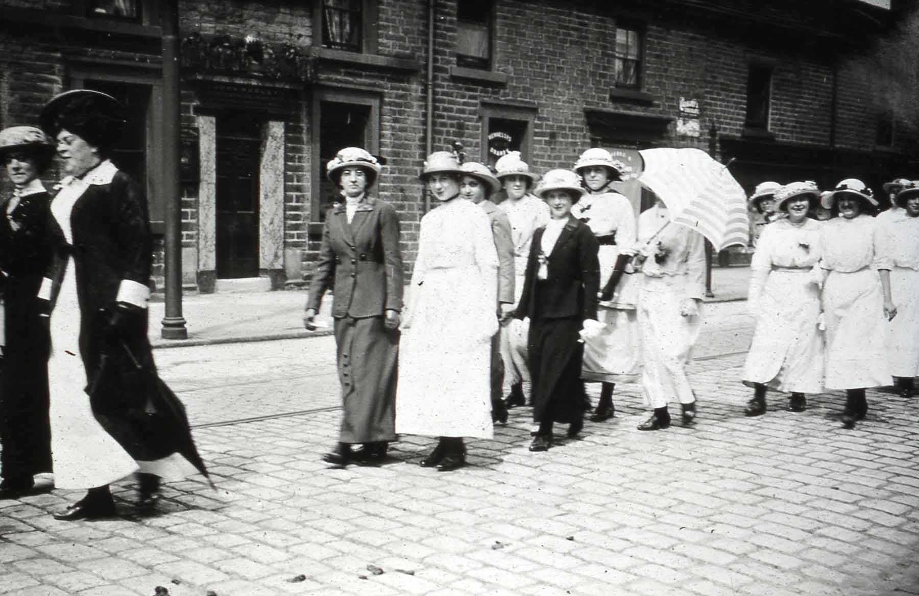
This probably a Whitsun parade walking west along High Street West with Edwin Lester’s fruiterer shop (right). Image from a digital collection by Bert Baker.
3050 ~ 142 High Street West~Fones Mart ~ (1910)
This probably a Whitsun parade walking west along High Street West with Isaac Shorrock’s, Baker & Confectioner shop (centre-right). Image from a digital collection by Bert Baker.
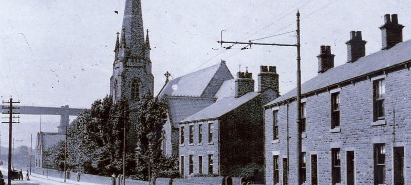
3049 ~ 144 High Street West~The Globe Public House ~ (1910)
This probably a Whitsun parade walking west along High Street West with The Globe pub (left). Image from a digital collection by Bert Baker.
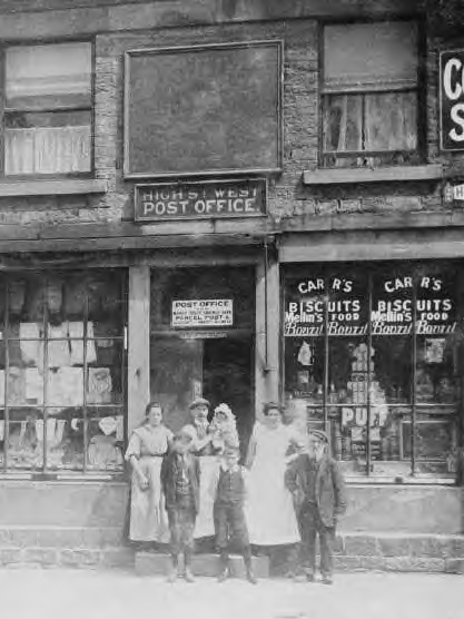
3048 ~ 4 Victoria Street~Old Post Office ~ (1936)
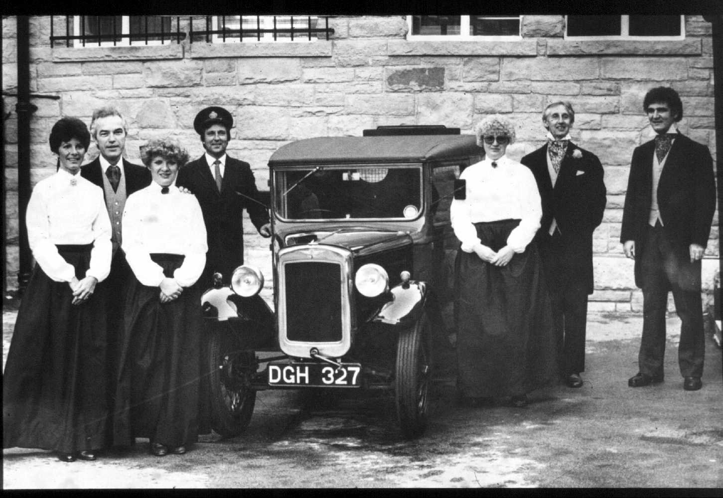
1936 or is it a Glossop Victorian Weekend re-creation? A 1936 Austin Seven Type AVH Royal Mail Van and Post Office staff, probably in the yard next to the old Post Office / market hall building. DGH327 was preserved and more photos can be seen on Flickr, search "DGH327". Image from a digital collection by Bert Baker.
3047 ~ 12 High Street West~Co-op Travel ~ (1920)
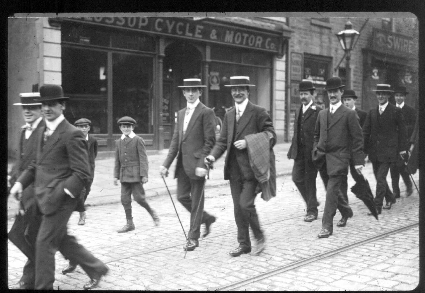
Glossop Cycle and Motor Company shop is left. Image from a digital collection by Bert Baker.
3046 ~ 10 High Street West~Roy Green Quality Butchers ~ (1920)
Frank Hazlewood’s hair dresser is probably in the middle. Hazlewood Frank, hair dresser
3045 ~ 8 High Street West~Debra Charity Shop ~ (1920)
John Swire and Son’s shop is right. Image from a digital collection by Bert Baker.
3044 ~ 4 Victoria Street~Old Post Office ~ (1923)
The new Post Office opens with a group photo. Image from a digital collection by Bert Baker.
3043 ~ George Street~ ~ (1923)
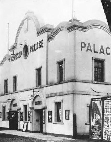
Glossop Palace theatre, the poster looks like "Tiger Rose" with Lenore Ulric, which was released in 1923. The poster on the right shows admission prices, 1’, 8d, 4½d with Saturday matinee 2d. Image from a digital collection by Bert Baker.
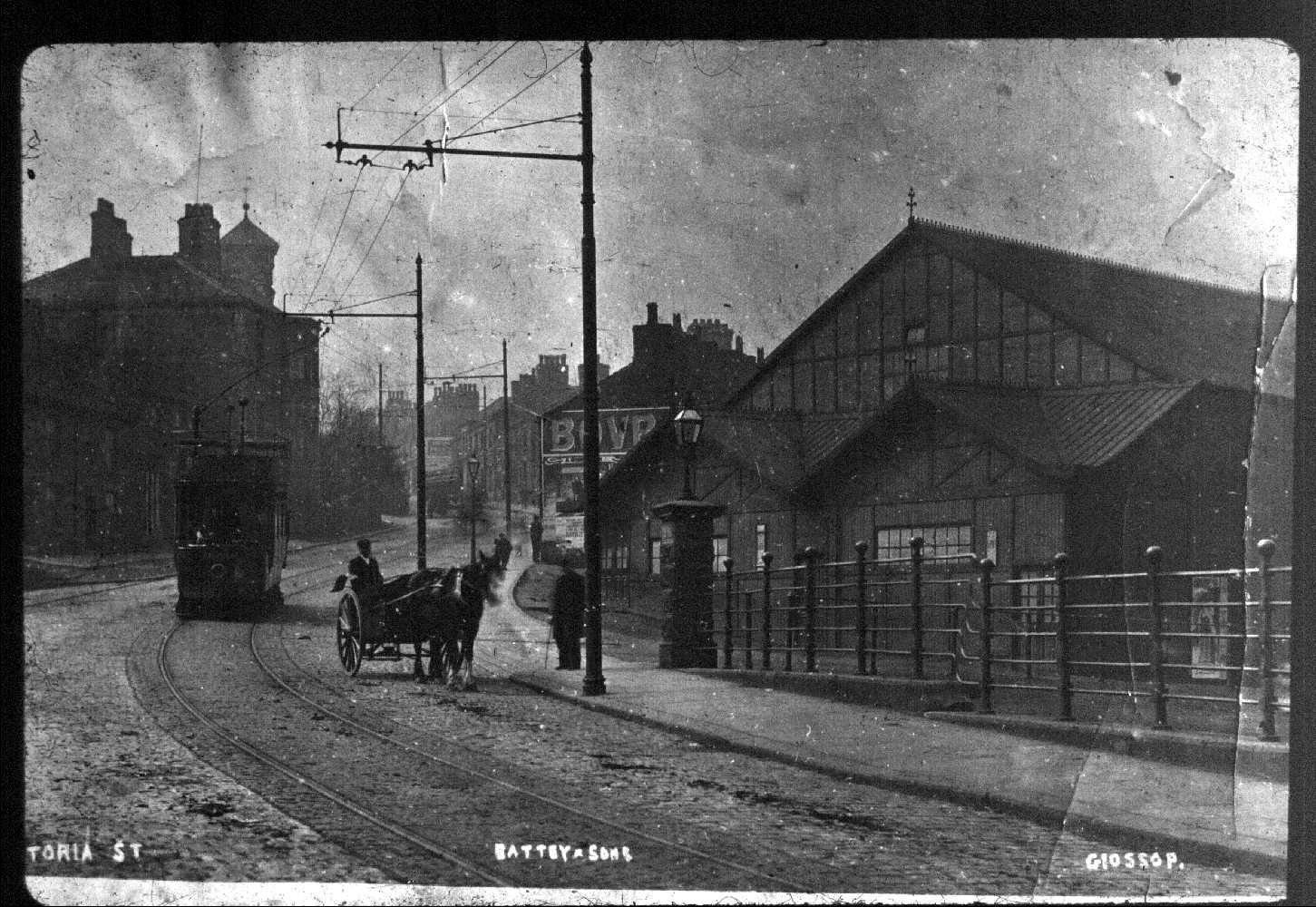
3042 ~ Victoria Street~Bodycheck ~ (1890)
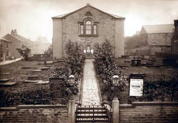
Littlemoor Congregational Church. Image from a digital collection by Bert Baker.
3041 ~ 14 High Street East~Crofter ~ (1911)
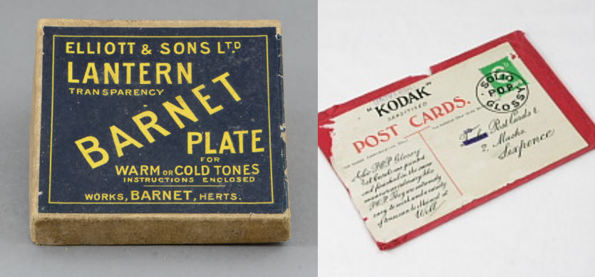
In the shop window above: Kodaks Solio POP were photograhy papers (Print Out Paper), postcard sized with postcard printing on one side. Barnet Plates were glass plates used by photographers before film was available.
3040 ~ 14 High Street East~Crofter ~ (1910)
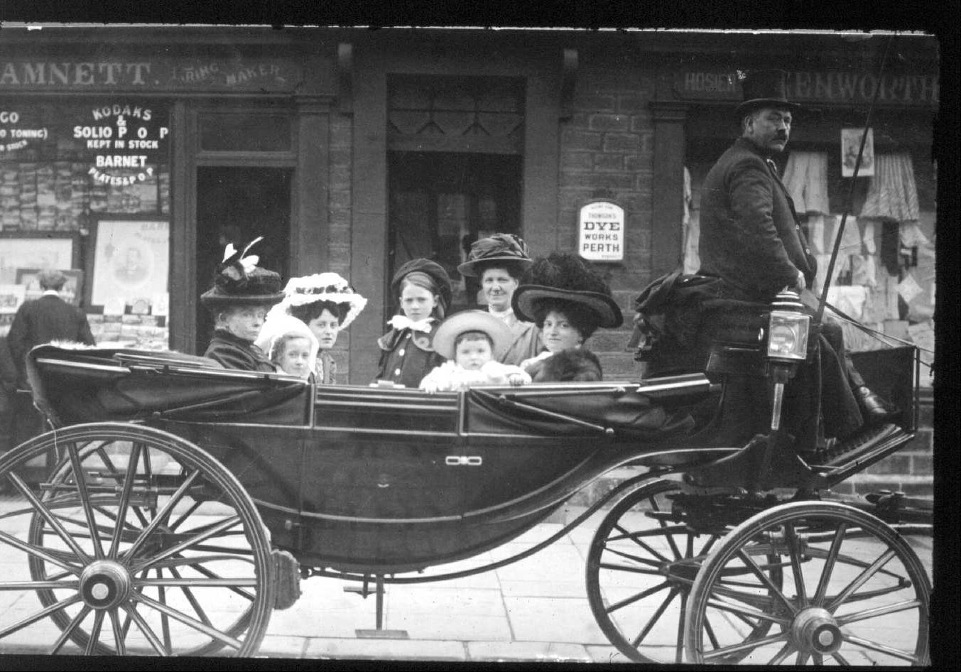
Presume it’s James Bennett’s photography shop / James Hamnett’s watch & clock makers shop (left) and Elizabeth Kenworthy’s drapers shop (right).
3039 ~ 99 - 151 High Street East~Formerly the Mechanic's Arms ~ (1900)
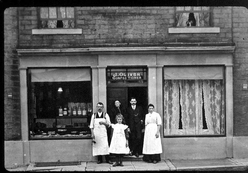
This is probably J Oliver’s confectionary shop at 103 High Street East, numbers 99 to 107 (5 houses / shops) are no longer there. Image from a digital collection by Bert Baker.
3038 ~ 4 High Street West~Corner Cupboard Sandwitch Bar ~ (1910)
Fish merchants. Image from a digital collection by Bert Baker.
3037 ~ Norfolk Square~Old Co-op Building ~ (1910)
Old Co-op building with cast iton and glass canopy. Image from a digital collection by Bert Baker.
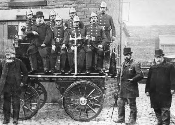
3036 ~ Ellison Street~ ~ (1890)
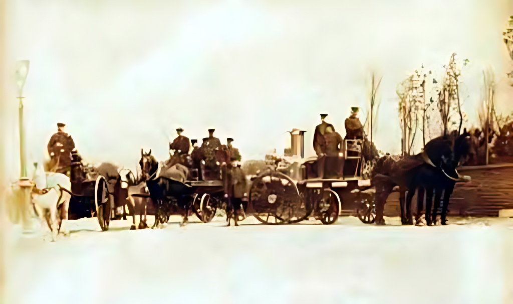
Horse drawn fire engines. Image from a digital collection by Bert Baker.
3035 ~ 8 - 10 Norfolk Street~Pick a Card ~ (1910)
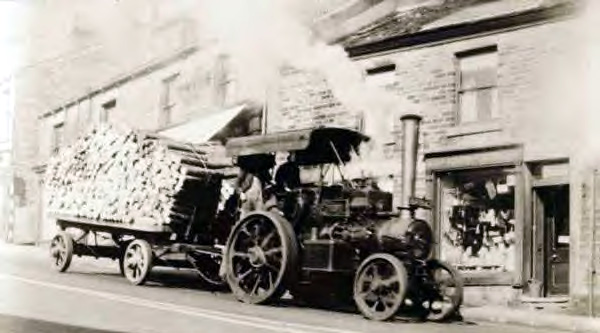
Traction engine steams down Norfolk Street with a trailor full of wooden logs. Does that look like a photography shop? Was the photo taken by the shop owner, Ernest Battey? Image from a digital collection by Bert Baker.
3033 ~ Victoria Street~ ~ (1910)
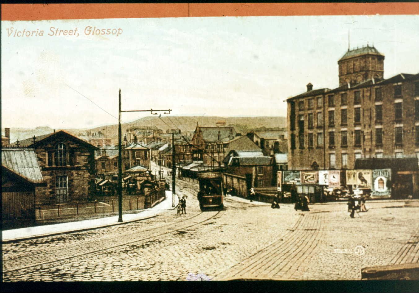
Victoria Street, market ground on the left and Howard Town Mill on the right. Image from a digital collection by Bert Baker.
3032 ~ 40-94 Victoria Street~ ~ (1910)
Victoria Street, the shop far left is most likely to be George Dale’s newsagent. Image from a digital collection by Bert Baker.
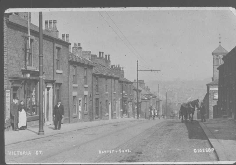
3031 ~ Victoria Street~ ~ (1910)
Victoria Street look back towards Glossop town centre. Image from a digital collection by Bert Baker.
3030 ~ Victoria Street~ ~ (1910)
Victoria Street and the Theatre Royal. Image from a digital collection by Bert Baker.
3029 ~ St James' Church~Whitfield ~ (1920)
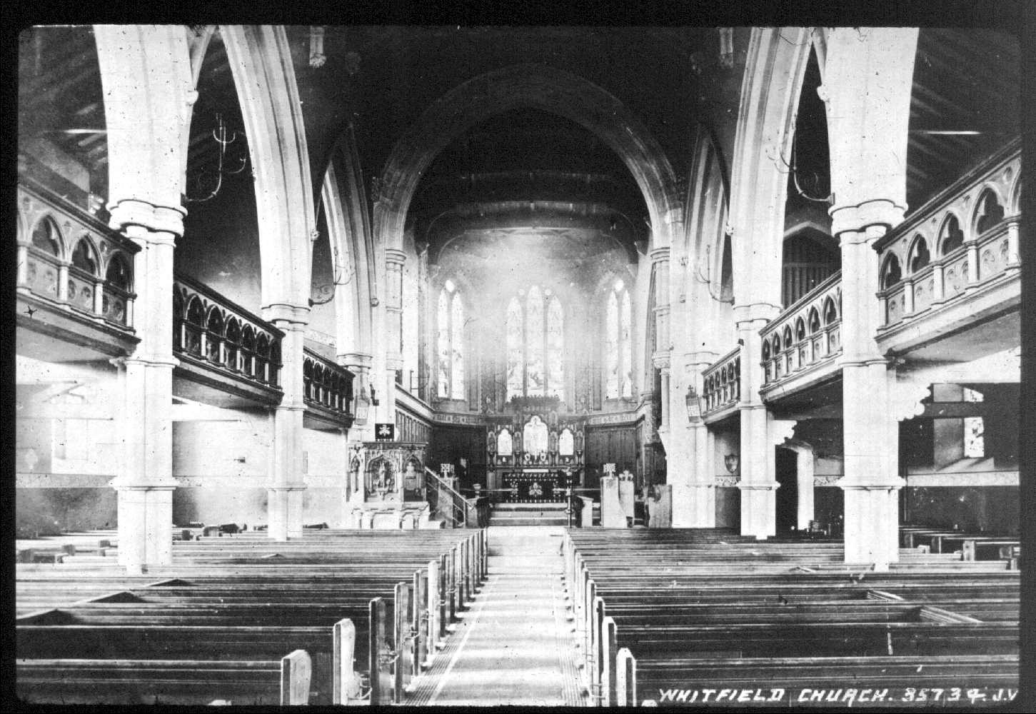
The inside of St James’ Church. Image from a digital collection by Bert Baker.
3028 ~ Charlestown Road~Turn Lee Mill ~ (1910)
St James’ Church, James Street and Charlestown Road. Image from a digital collection by Bert Baker.
3027 ~ James Street~ ~ (1910)
St James’ Church, James Street and Charlestown Road. Image from a digital collection by Bert Baker.
3026 ~ St James' Church~Whitfield ~ (1910)
St James’ Church, James Street and Charlestown Road. Image from a digital collection by Bert Baker.
3025 ~ Norfolk Square~Norfolk Arms ~ (1950)

Norfolk Square, Partington Theatre, Nat West Bank and Norfolk Arms. What was the street called on the far left? Image from a digital collection by Bert Baker.
3024 ~ Norfolk Square~Partington Theatre ~ (1950)
Norfolk Square, Partington Theatre, Nat West Bank and Norfolk Arms. What was the street called on the far left? Image from a digital collection by Bert Baker.
3023 ~ Norfolk Square~Nat West Bank ~ (1950)
Norfolk Square, Partington Theatre, Nat West Bank and Norfolk Arms. What was the street called on the far left? Image from a digital collection by Bert Baker.
3022 ~ Norfolk Square~ ~ (1950)
Norfolk Square, Partington Theatre, Nat West Bank and Norfolk Arms. What was the street called on the far left? Image from a digital collection by Bert Baker.
3021 ~ Norfolk Square~Nat West Bank ~ (1905)
.jpg)
Norfolk Square and the Manchester & County Bank. Image from a digital collection by Bert Baker.
3020 ~ Norfolk Square~ ~ (1905)
Norfolk Square. Image from a digital collection by Bert Baker.
3019 ~ Norfolk Square~ ~ (1930)
Morris dancers in Norfolk Square, let us know if you know the year? Image from a digital collection by Bert Baker.
3018 ~ 1-3 Market Arcade~Various ~ (1905)
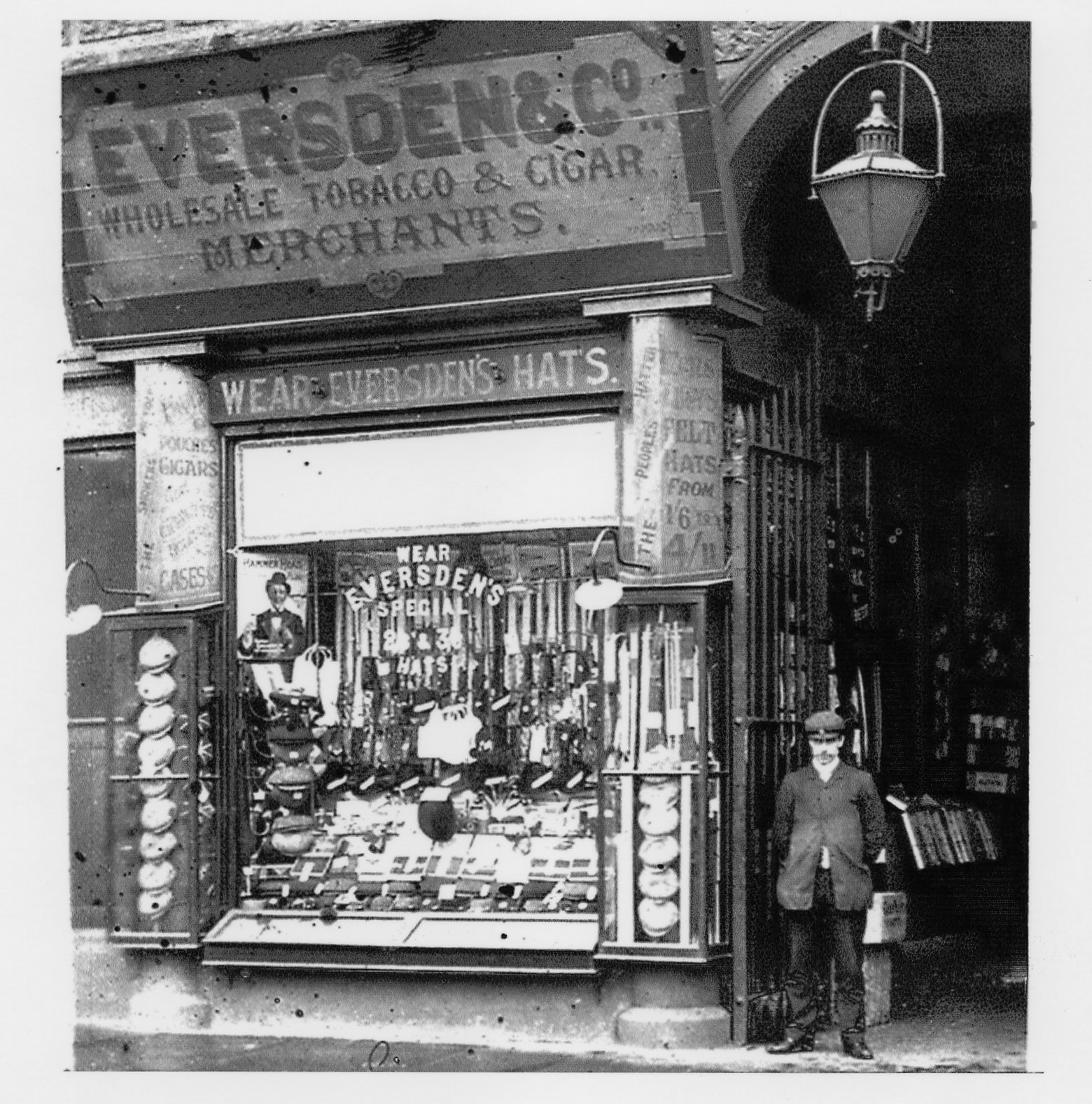
Eversden & Co. Wholesale Tobacco & Cigar Merchants also selling hats, "Felt hats from 1’ 6". Image from a digital collection by Bert Baker.
3017 ~ Plough Inn~Dinting Vale ~ (1960)
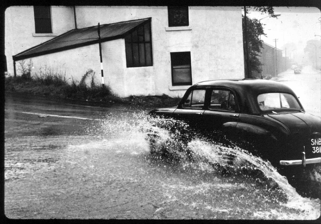
Is that an Austin A30 ploughing through the flood water at the junction for the Marple to Glossop road, the Plough Inn (out of shot) was opposite this white building. Image from a digital collection by Bert Baker.
3016 ~ Outdoor Market~Various ~ (1910)
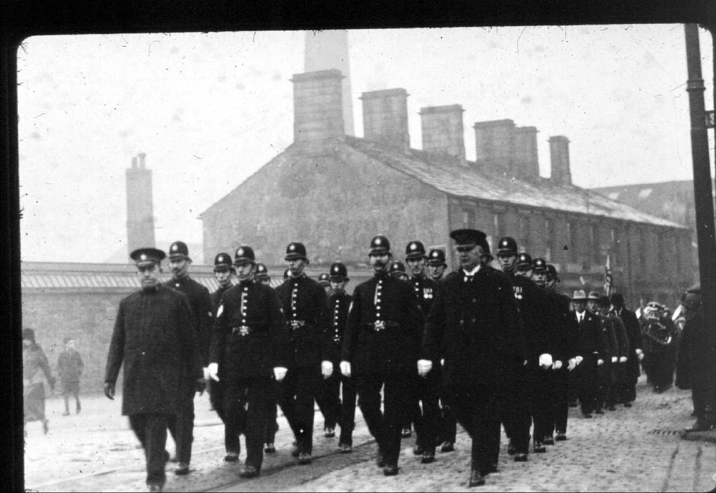
The Glossop police force on the market ground. Image from a digital collection by Bert Baker.
3015 ~ Ellison Street~ ~ (1910)
The Poice Station was in Ellison Street although this photo looks like it was taken on the market ground. Image from a digital collection by Bert Baker.
3014 ~ Ellison Street~ ~ (1900)
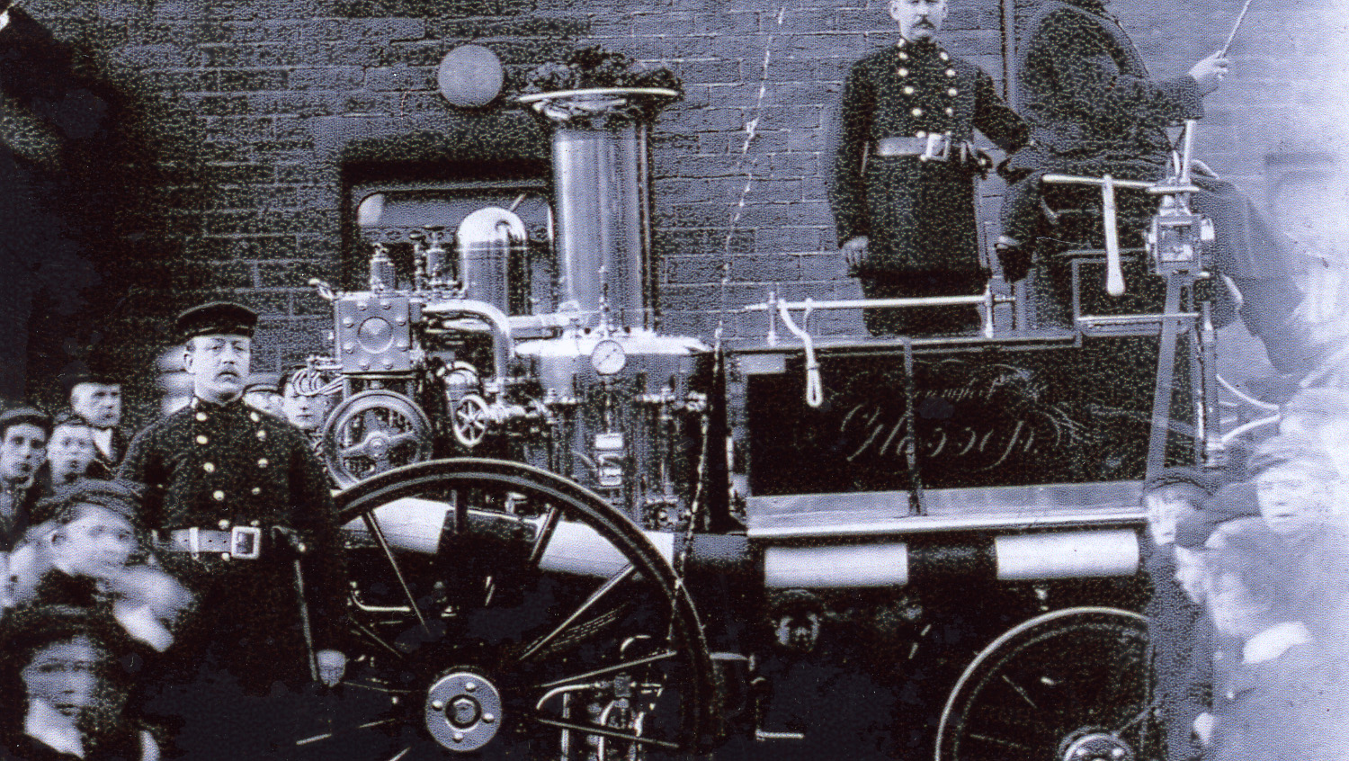
Glossop Fire Brigade with their shiny new fire engine. Image from a digital collection by Bert Baker.
3013 ~ Ellison Street~ ~ (1940)
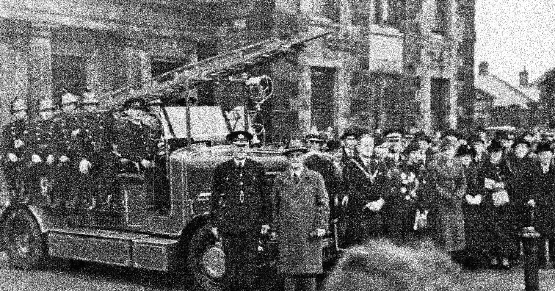
The Police and Fire Station was located on Ellison Street although this photo was probably take outside the Municipal building. Image from a digital collection by Bert Baker.
3012 ~ Ellison Street~ ~ (1900)
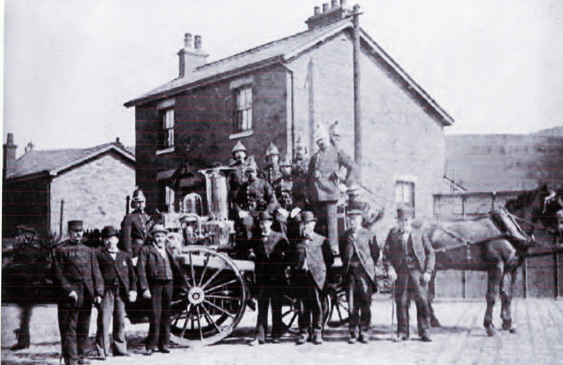
The Police and Fire Station was located on Ellison Street. Image from a digital collection by Bert Baker.
3011 ~ Ellison Street~ ~ (1900)
The Police and Fire Station was located on Ellison Street. Image from a digital collection by Bert Baker.
3010 ~ 38-42 High Street West~The Courtyard Kitchens ~ (1940)
Probably 40 Hight Street West, Hunters grocers shop. Image from a digital collection by Bert Baker.
3009 ~ 30 - 40 High Street East~Leisure Centre / Kwik Fit ~ (1910)
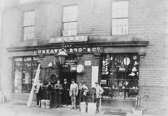
34 High Street East, J. Merry - Greaves Brothers & company ironmongers and gas light shop. Image from a digital collection by Bert Baker.
3008 ~ Railway Station~B&M & Railway Station ~ (1941)
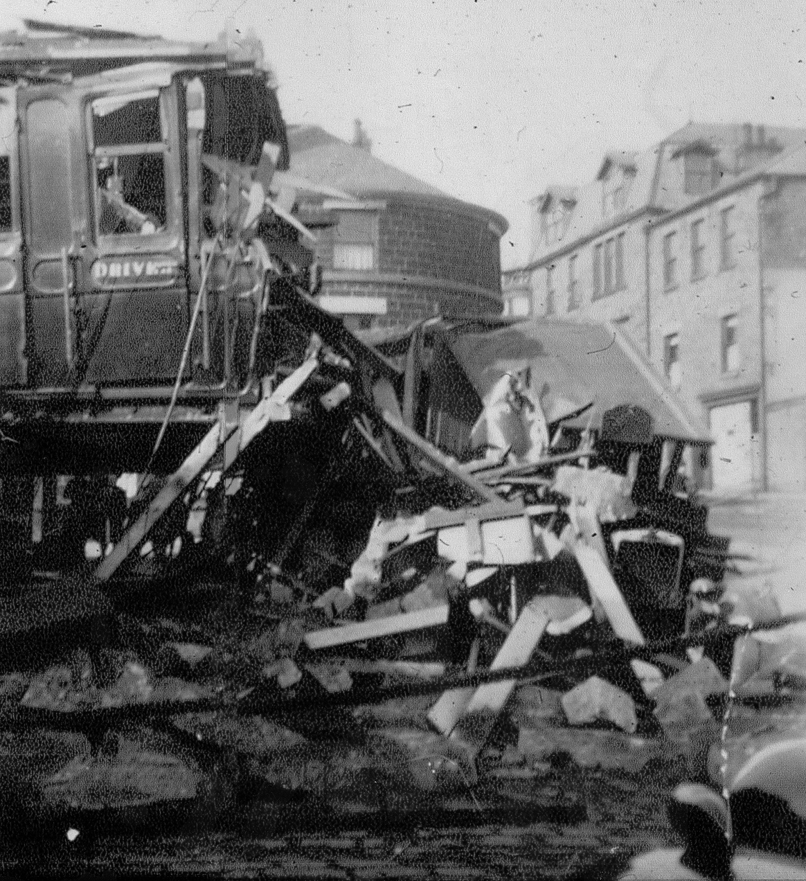
There have been two occasions when trains have gone through the buffers at Glossop station, one in 1949 and this one in 1941. Image from a digital collection by Bert Baker.
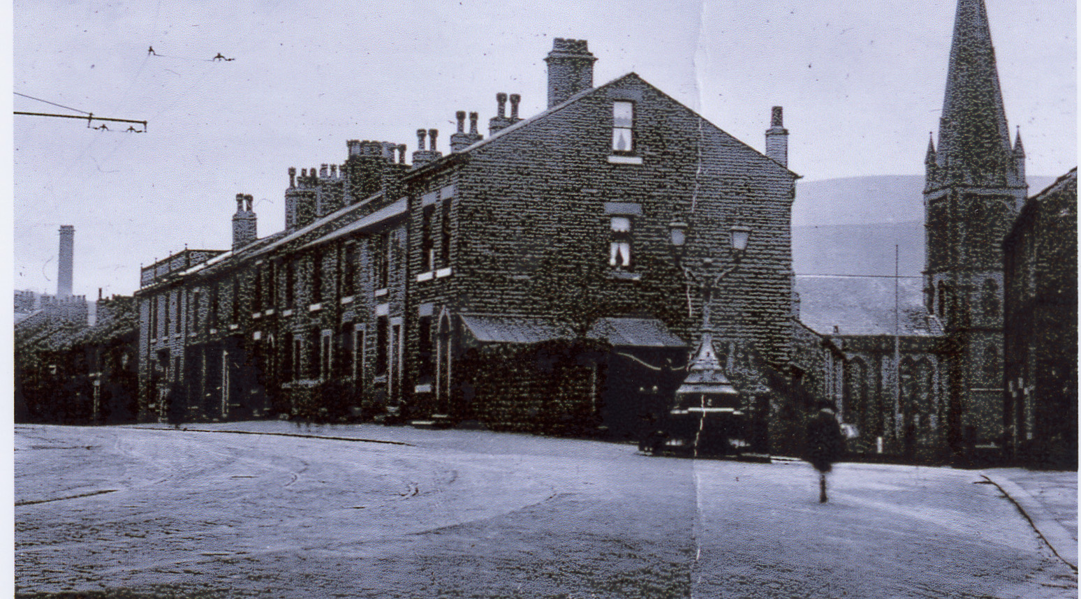
3007 ~ 146 - High Street West~ ~ (1910)
244 High Street West Post Office. Image from a digital collection by Bert Baker.
3006 ~ 163 - 211 High Street East~ ~ (1910)
High Street East between Jordan Street and Manor Park Road (right) which was Hall Street in the black and white days. Image from a digital collection by Bert Baker.
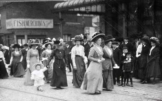
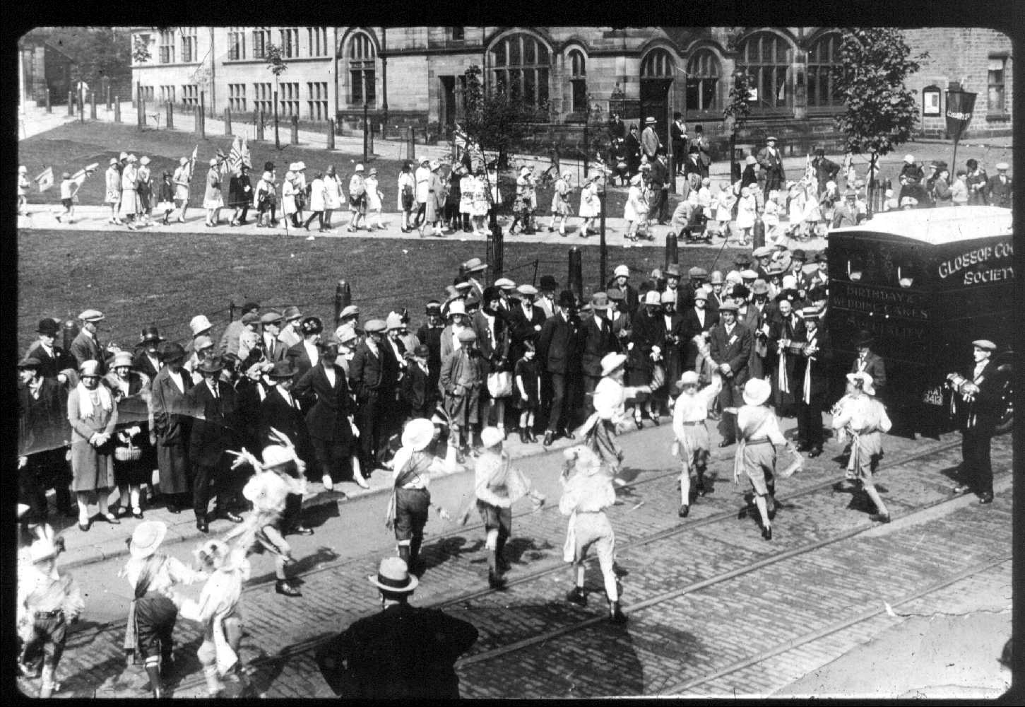
3005 ~ Outdoor Market~Various ~ (1910)
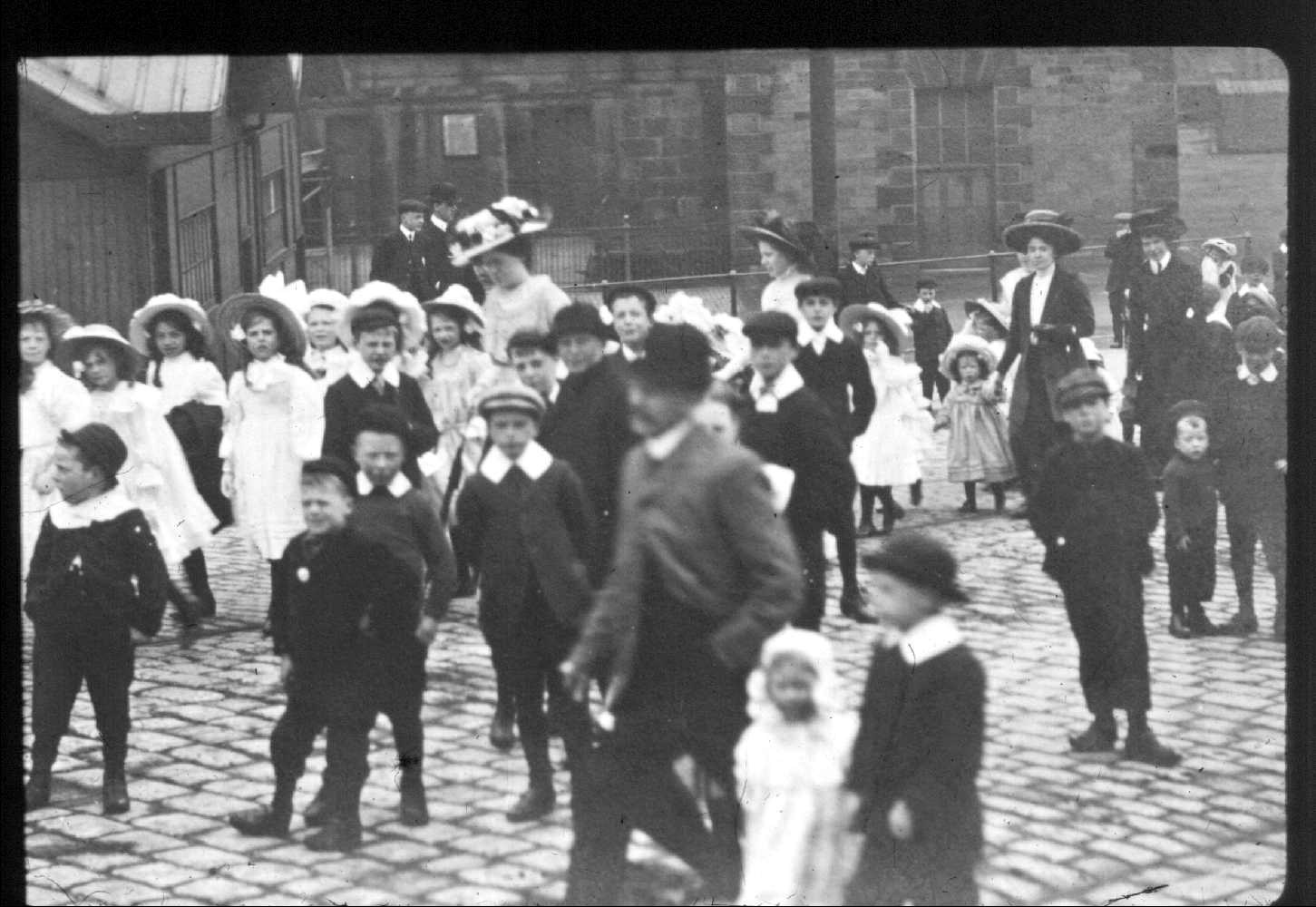
This looks like the market ground and a church procession or cotton queen procession. Image from a digital collection by Bert Baker.
3004 ~ Outdoor Market~Various ~ (1910)
Early 20th century, the title of this photo is ’Bull Roasting at Glossop Market’. Image from a digital collection by Bert Baker.
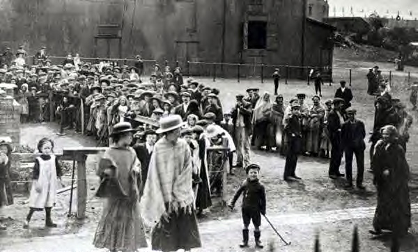
3003 ~ All Saints Church~Old Glossop ~ (1915)
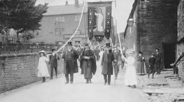
Church procession at All Saints Church, Old Glossop. Image from a digital collection by Bert Baker.
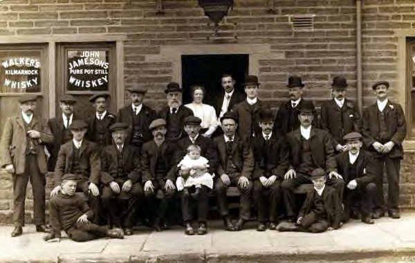
3002 ~ Bulls Head~Old Glossop ~ (1915)
Church procession with the Bulls Head in the background. Image from a digital collection by Bert Baker.
3001 ~ Norfolk Square~Old Co-op Building ~ (1910)
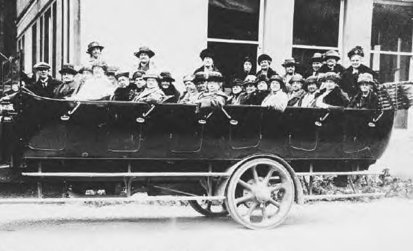
Early 20th century, the Glossop Co-op ladies on an outing, photo probably taken at their destination. Image from a digital collection by Bert Baker.
3000 ~ 14 Norfolk Street~The Tan Bar ~ (1920)
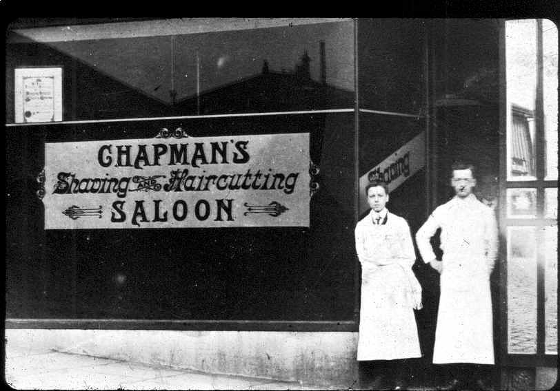
Presume the two gentlemen in the door way were the Chapman brothers. Image from a digital collection by Bert Baker.
2999 ~ Dinting Lane~ ~ (1910)
Dinting Lane looking up towards the railway track from Dinting Vale. Image from a digital collection by Bert Baker.
2998 ~ 15 -17 High Street East~Howard Arms ~ (1920)
Group photo outside the Howard Arms, presume the lady and gent in the door were the licencees. Image from a digital collection by Bert Baker.
2997 ~ The Grouse~Chunnal ~ (1930)
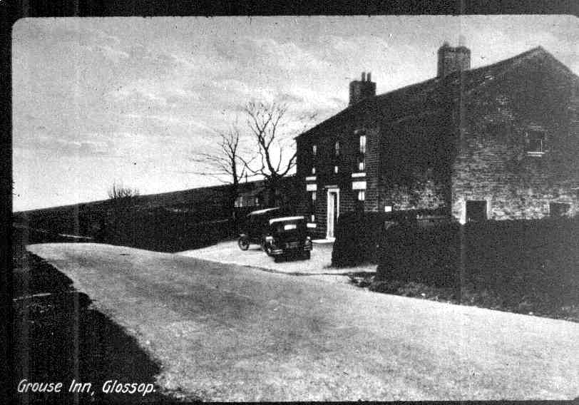
A postcard of the Grouse Inn. Image from a digital collection by Bert Baker.
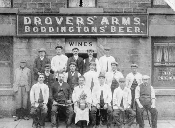
2996 ~ Drover's Arms~Charlestown ~ (1890)
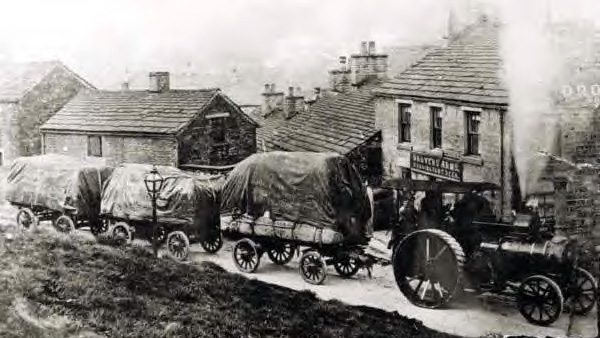
Traction engine and trailors going past the Drover’s Arms, must be late 19th century? How narrow does that road look. Image from a digital collection by Bert Baker.
2995 ~ Bulls Head~Old Glossop ~ (1903)
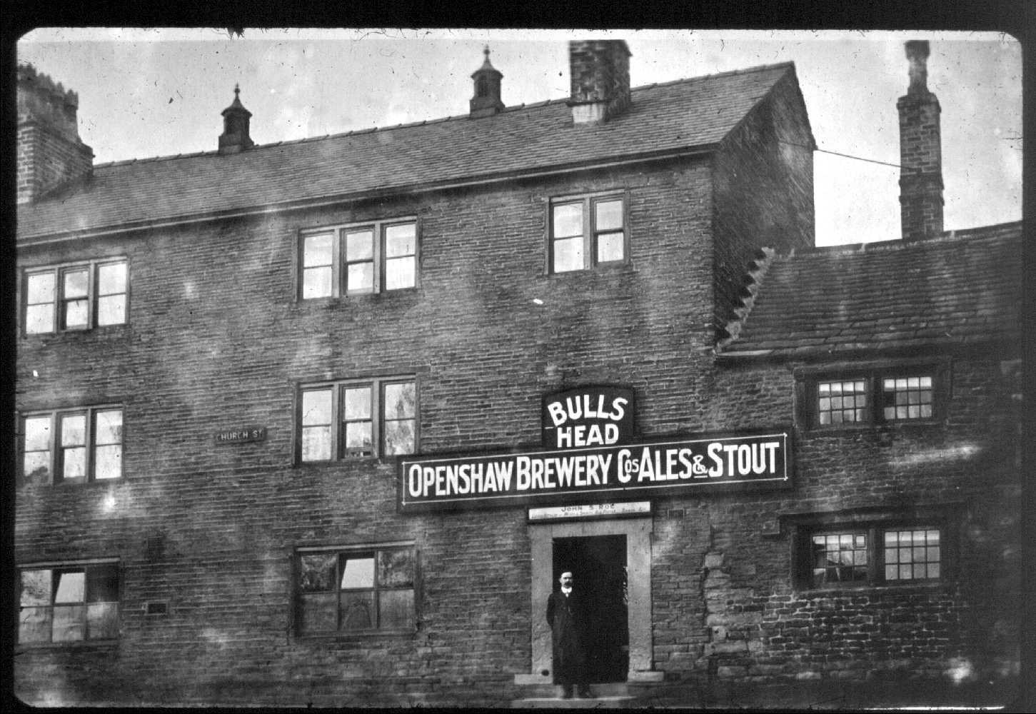
Bulls Head, Old Glossop, name above the door says John S Roe, presumably this is John stood in the doorway. John Samuel Roe was licencee from 1903 to 1924. Image from a digital collection by Bert Baker.
2994 ~ Bulls Head~Old Glossop ~ (1980)
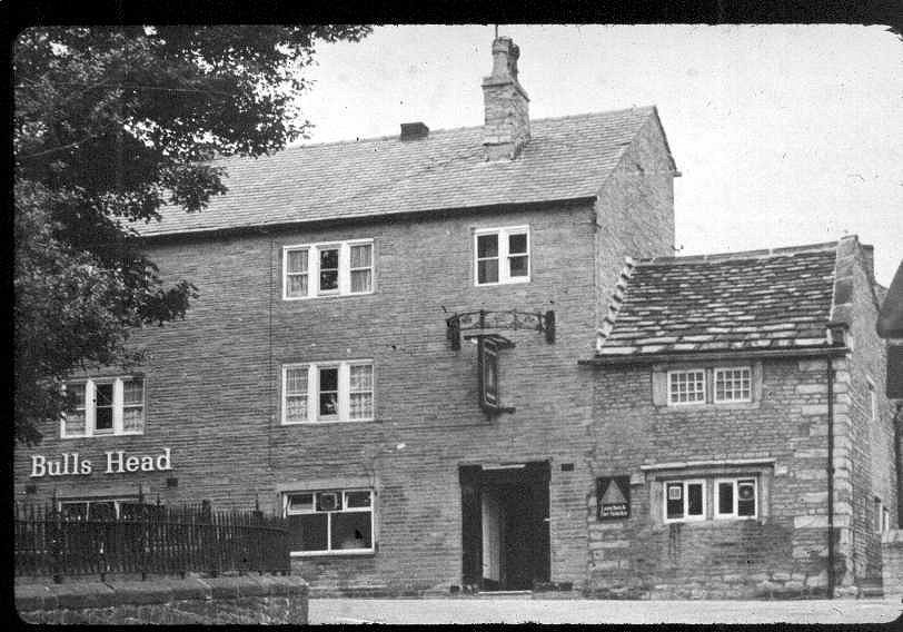
Bulls Head, Old Glossop, maybe 70s or 80s, when was the half ring added? When was the pub name to the left? Image from a digital collection by Bert Baker.
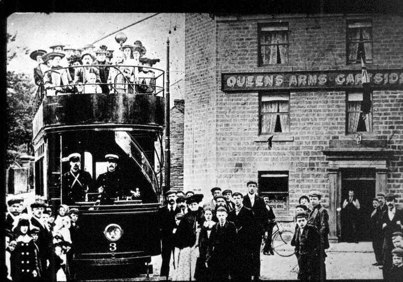
2993 ~ The Queens~Old Glossop ~ (1903)
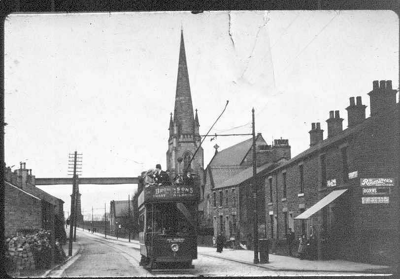
Number 3 tram stands outside the Queen’s Arms in Old Glossop. These dark green and primrose double-decker trams operated from 1903 to 1927. Image from a digital collection by Bert Baker.
2992 ~ Royal Oak Inn~Brookfield ~ (1905)
This could be the Royal Oak Inn on Brookfield, the sign above the door looks like Robert God... Robert Goddard was the lincencee of the Royal Oak Inn from 1903 to 1906. This row of house have long since gone, probably just after New Shaw Lane opposite Glossop Caravans. Image from a digital collection by Bert Baker.
2991 ~ Mill Street~ ~ (1912)
Kelly’s Directory
Ash Israel, shopkeeper, Mill street
2990 ~ Pikes Lane~ ~ (1941)
Kelly’s Directory
Bennett Fred, farmer, Pikes farm
Fielding Wltr. beer retlr. 130 Pike’s la
Hinchliffe Annie (Mrs.), draper, 62 Pike’s la
Milburn Tom, beer retlr. 40 Pike’s la
Rymer Fred, fried fish dlr. 126 Pike’s la
Sims Lily (Mrs.), baker, 106 Pike’s la
Timperley Jsph. baker, 38 Pike’s la
2989 ~ Pikes Lane~ ~ (1932)
Kelly’s Directory
Bennett Fred, farmer, Pikes farm
Dale Rd. baker, 106 Pike’s Ia
Fennel’s fried fish dlr. 126 Pike’s Ia
Fielding Walt. shopkpr. 130 Pike’s Ia
Glossop Dale New Industrial Co-operative Society Ltd. (J. T. Hyde, sec.), Norfolk sq. (T N 15); 14, 46 & 48 & 369 High st. west; 20 Charlestown rd.; Manor Park rd.; Pike’s la.; Church st. south; 106 Gladstone st. & 47 Surrey st.; registered office, 2 Railway st
Hancock Beatrice (Mrs.), dressma. 57 Pike’s Ia
Manns Mary Jane (Mrs.), shopkpr. 104 Pike’s is
Mellor Annie (Miss), ladies’ hairdrssr. 40 Pike’s Ia
Mellor Charles, beer retailer, 40 Pike’s lane
Sidebottom D. & T. joiners, 1 Pike’s Ia. & Victoria st. T N 184
2988 ~ Pikes Lane~ ~ (1925)
Kelly’s Directory
Glossop Dale New Industrial Co-operative Society Ltd. (J. T. Hyde, sec.), Norfolk square (T N 15); 14, 46 & 48 & 369 High street west; 20 Charlestown road ; Hall street ; Pike’s lane ; Church street south ; 106 Gladstone street & 47 Surrey street ; registered office, 2 Railway street
Hallows Hannah (Miss), shopkeeper, 106 Pike’s lane
Manns Mary Jane (Mrs.), draper, 104 Pike’s lane
Marsden Edward, farmer, Pike’s farm
Mellor Charles, beer retailer, 40 Pike’s lane
Newton John, shopkeeper, 130 Pike’s lane
Phillips Alfred, clerk to the Glossop Local Pensions Committee, 53 Pike’s lane
Taylor Robert, insurance agent, 39 Pike’s lane
Timperley Joseph, shopkeeper, 38 Pike’s lane
2987 ~ Pikes Lane~ ~ (1912)
Kelly’s Directory
Blackburn William Arthur, insurance agent, 67 Pike’s la
Boyd Henry, shopkeeper, 97 Pike’s lane
Glossop Dale New Industrial Co-operative Society Lim. (John T. Hyde, sec.), Norfolk square; 369 High street west; Charlestown road; Hall street; Pike’s lane;
Hallows Hannah (Mrs.), shopkeeper, 106 Pike’s lane
Haynes Thomas, surveyor to corporation, Town hall, High street west & Pike’s lane
Jepson Joseph, insurance agent, 50 Pike’s lane
Manns Mary Jane (Mrs.), draper, 104 Pike’s lane
Newton John, grocer & beer retailer, 130 Pike’s lane
Phillips A. & J. carriers, Pike’s lane & Surrey street
Ridgeway Edward, beer retailer (off), 40 Pike’s lane
Stafford James, boot repairer, 26 Pike’s lane
Taylor Robert, insurance agent, 8 Pike’s lane
Thornley George, insurance agent, 124 Pike’s lane
2986 ~ Pikes Lane~ ~ (1910)
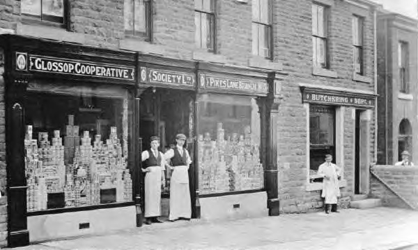
Glossop Cooperative Society Ltd. Pikes Lanch with Butchering Dept. next door. Image from a digital collection by Bert Baker.
2984 ~ 80 High Street West~Pizza Plus ~ (1900)
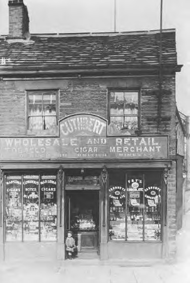
Cuthbert - Wholesale & Retail Tobacco Cigar Merchant. Image from a digital collection by Bert Baker.
2983 ~ Manor Street~ ~ (1900)
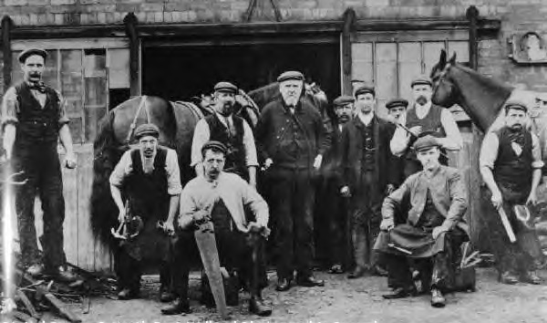
Boardman and Sons blacksmiths in Manor Street, Glossop. Image from a digital collection by Bert Baker.
2982 ~ Primrose Lane~ ~ (1920)
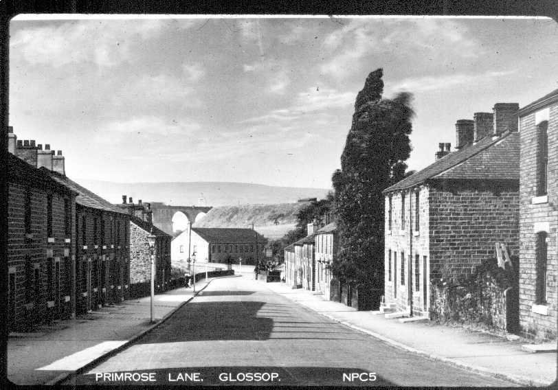
Primrose Lane looking towards High Street West and Dinting Viaduct, date could be any time in the first half of the 20th century, unless you know better? Image from a digital collection by Bert Baker.
2981 ~ Dinting School~Dinting Vale ~ (1899)
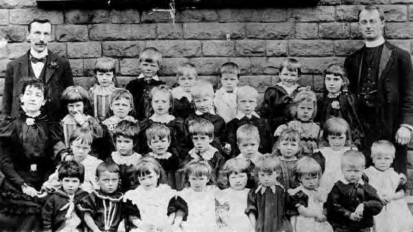
Dinting School class photo, do you know any names? Image from a digital collection by Bert Baker.
2980 ~ Dinting School~Dinting Vale ~ (1920)
Dinting School, far left, 1920s / 30s. Image from a digital collection by Bert Baker.
2979 ~ Mill Street~ ~ (1920)
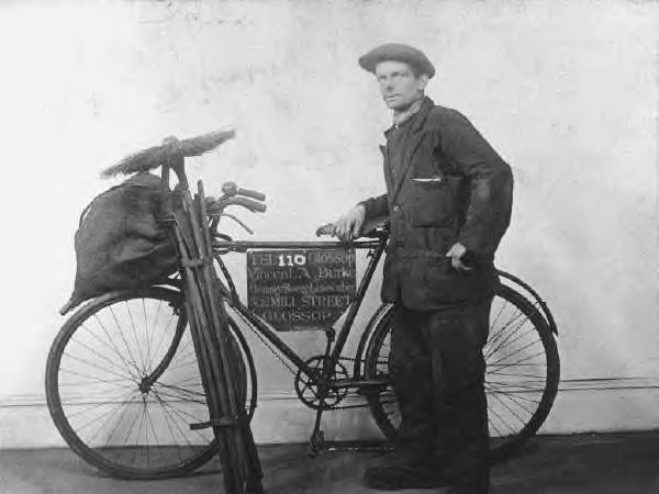
Glossop chimney sweep, sign on bike reads, ’TEL 110 Glossop, Vincent A Burke, Chimney Sweep Limewashing, & 2 MILL STREET, GLOSSOP’. Image from a digital collection by Bert Baker. Image from a digital collection by Bert Baker.
2978 ~ 379 High Street West~Formerly The Junction Inn ~ (1940)
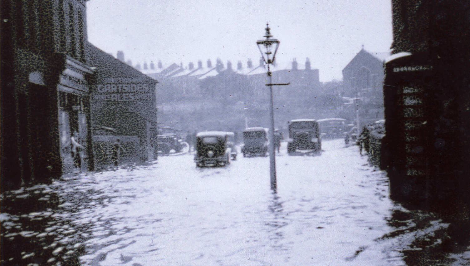
A flood on High Street West looking west towards the Zion Church on Simmondley Lane, with the Garsides Ales advert on the side of the Junction Inn. Note the K6 phone box on the right, these were introduced from 1936. Image from a digital collection by Bert Baker.
2977 ~ 60-64 High Street West~Sherefe Restraunt ~ (1962)
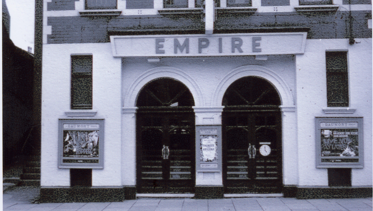
Gaumont, Empire Theatre, the poster in the left poster looks like ’Jack the Ripper’ (1959), middle looks like ’Thunder Over Arizona’ (1956) and the right poster looks like ’Live Now - Pay Later’ (1962). Image from a digital collection by Bert Baker.
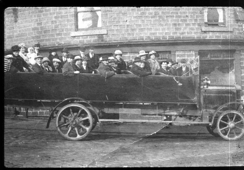
2976 ~ Drover's Arms~Charlestown ~ (1920)
Group photo outside the Drover’s Arms, Charlestown, is that a trophy being held by the man in the middle? Image from a digital collection by Bert Baker.
2975 ~ 138 High Street West~Residential ~ (2023)
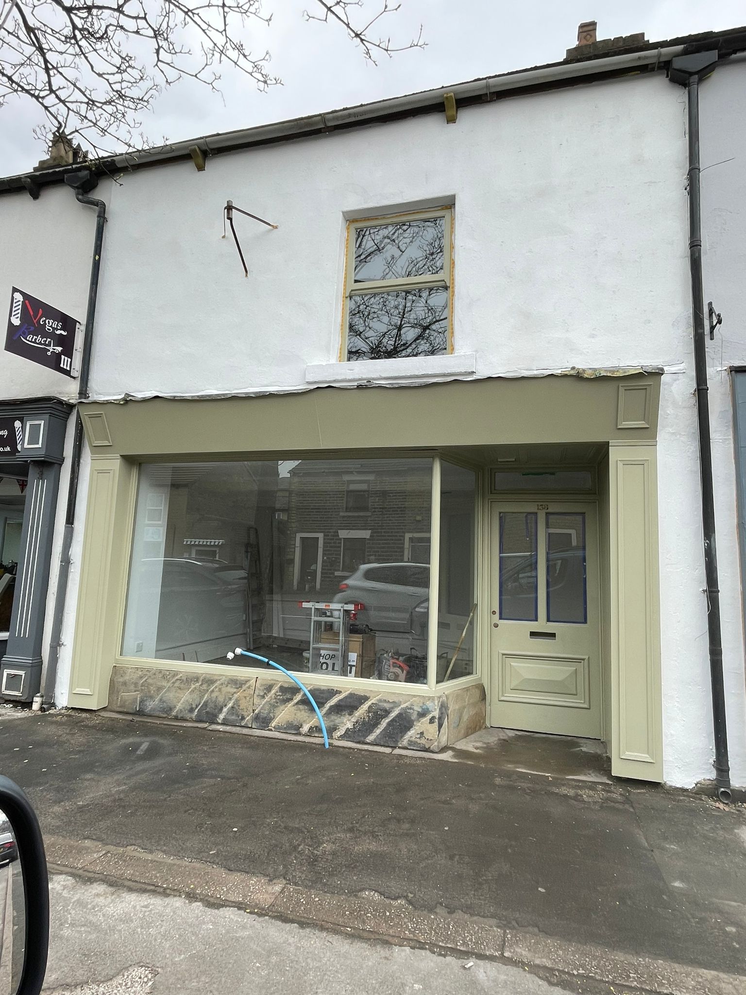
Shop undergoing renovation, the base of the window is simply three massive stone slabs. Photo courtesy of Chris Hales.
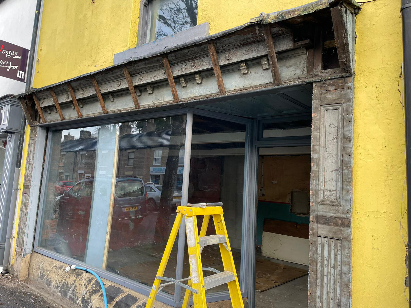
2974 ~ 138 High Street West~Residential ~ (2023)

Shop undergoing renovation showing original wall colours and stone flag floor. A 1799 George III halfpenny (badly worn) whilst renovating, it might have dropped out of the pocket of one of the original builders. Photo courtesy of Chris Hales.
2973 ~ 138 High Street West~Residential ~ (2023)
Shop undergoing renovation. Photo courtesy of Chris Hales.
2972 ~ Mason's Arms~Hadfield ~ (1920)
A charabang waits outside the Mason’s Arms, early 20th century. Image from a digital collection by Bert Baker.
2971 ~ Dinting~Holy Trinity Dinting Church ~ (1920)
Holy Trinity Dinting Church. Trams ran from 1903 to 1927. Image from a digital collection by Bert Baker.
2970 ~ Dinting~Holy Trinity Dinting Church ~ (1920)
Holy Trinity Dinting Church 1920s / 30s. Image from a digital collection by Bert Baker.
2969 ~ Dinting~Dinting Viaduct ~ (1930)
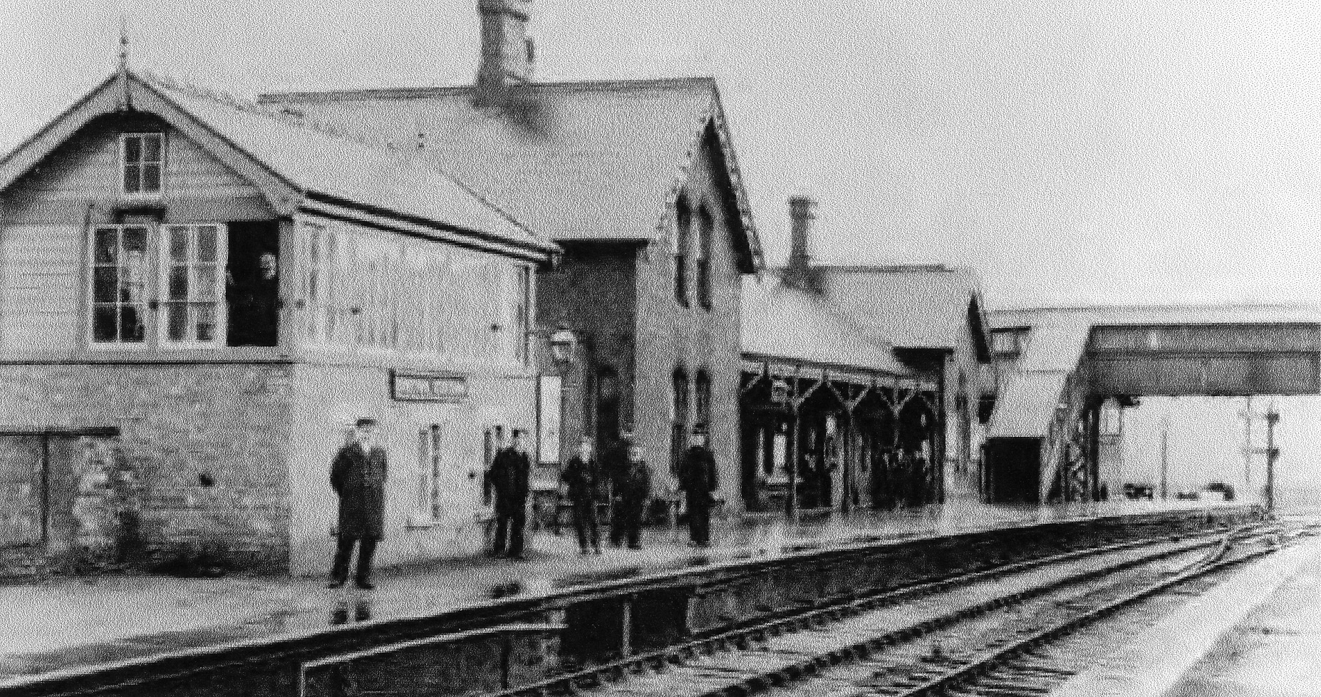
Dinting Station date sometime before electrificaion. Image from a digital collection by Bert Baker.
2968 ~ Dinting~Dinting Viaduct ~ (1970)
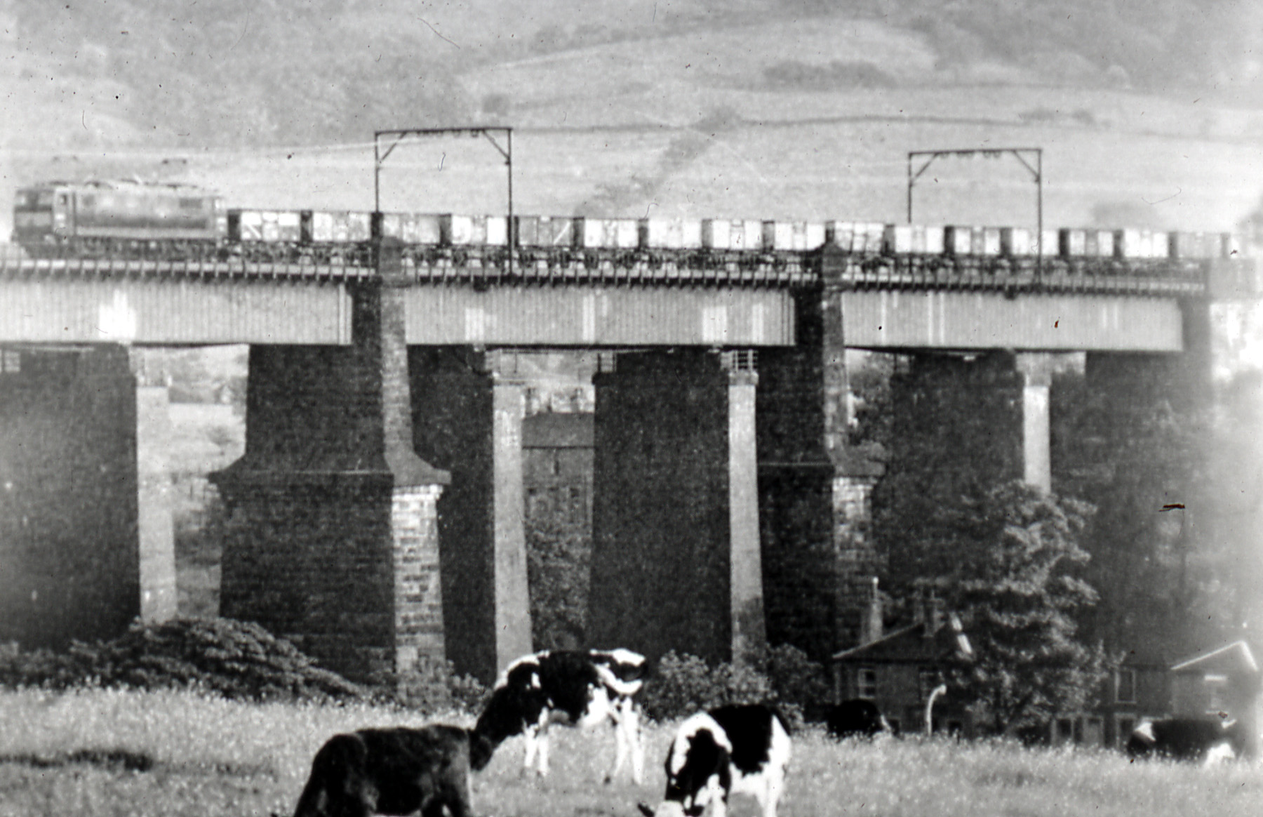
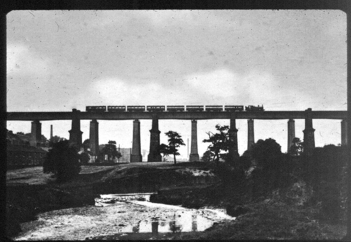
Freight train running across Dinting Viaduct. Image from a digital collection by Bert Baker.
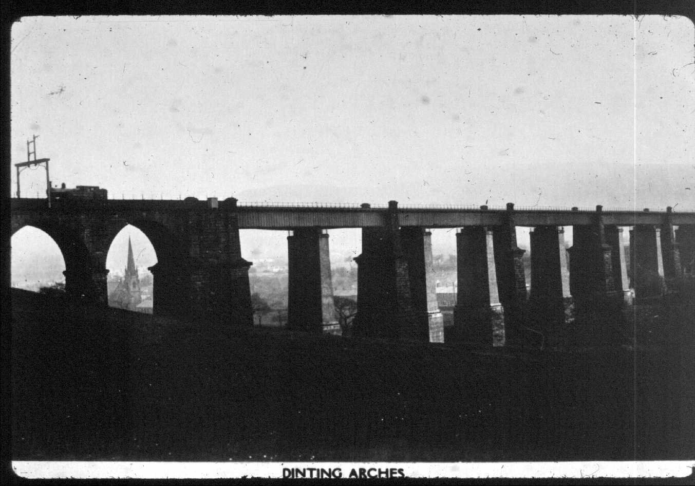
2967 ~ Dinting~Dinting Viaduct ~ (1910)
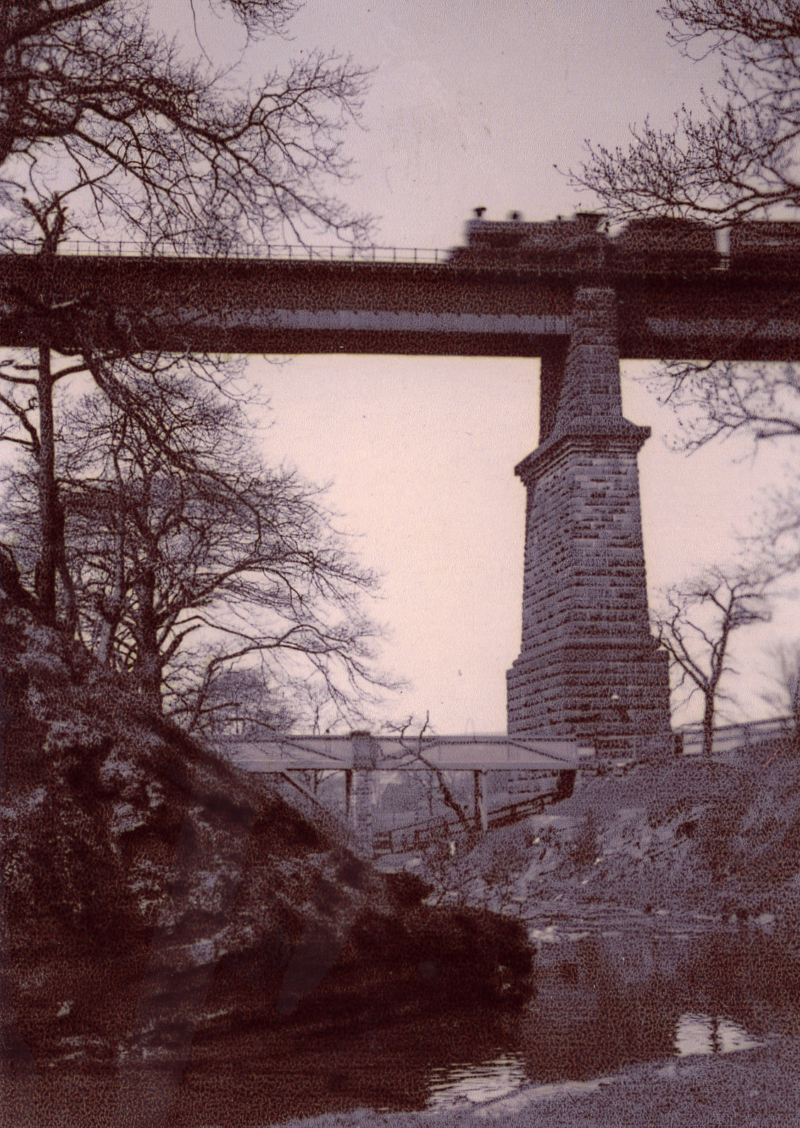
Train going accross Dinting Viaduct probably 1920s / 30s. Image from a digital collection by Bert Baker.
2966 ~ Dinting~Dinting Viaduct ~ (1930)
Train going accross Dinting Viaduct probably 1920s / 30s. Image from a digital collection by Bert Baker.
2965 ~ Dinting~Dinting Viaduct ~ (1930)
Train going accross Dinting Viaduct probably 1920s / 30s. Image from a digital collection by Bert Baker.
2964 ~ 1 High Street West~Edward Mellor Estate Agents ~ (2023)
test edit
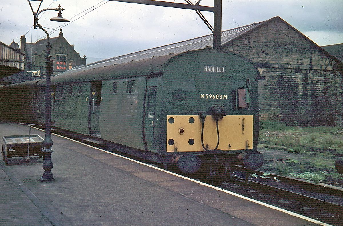
2963 ~ Railway Station~B&M & Railway Station ~ (1985)
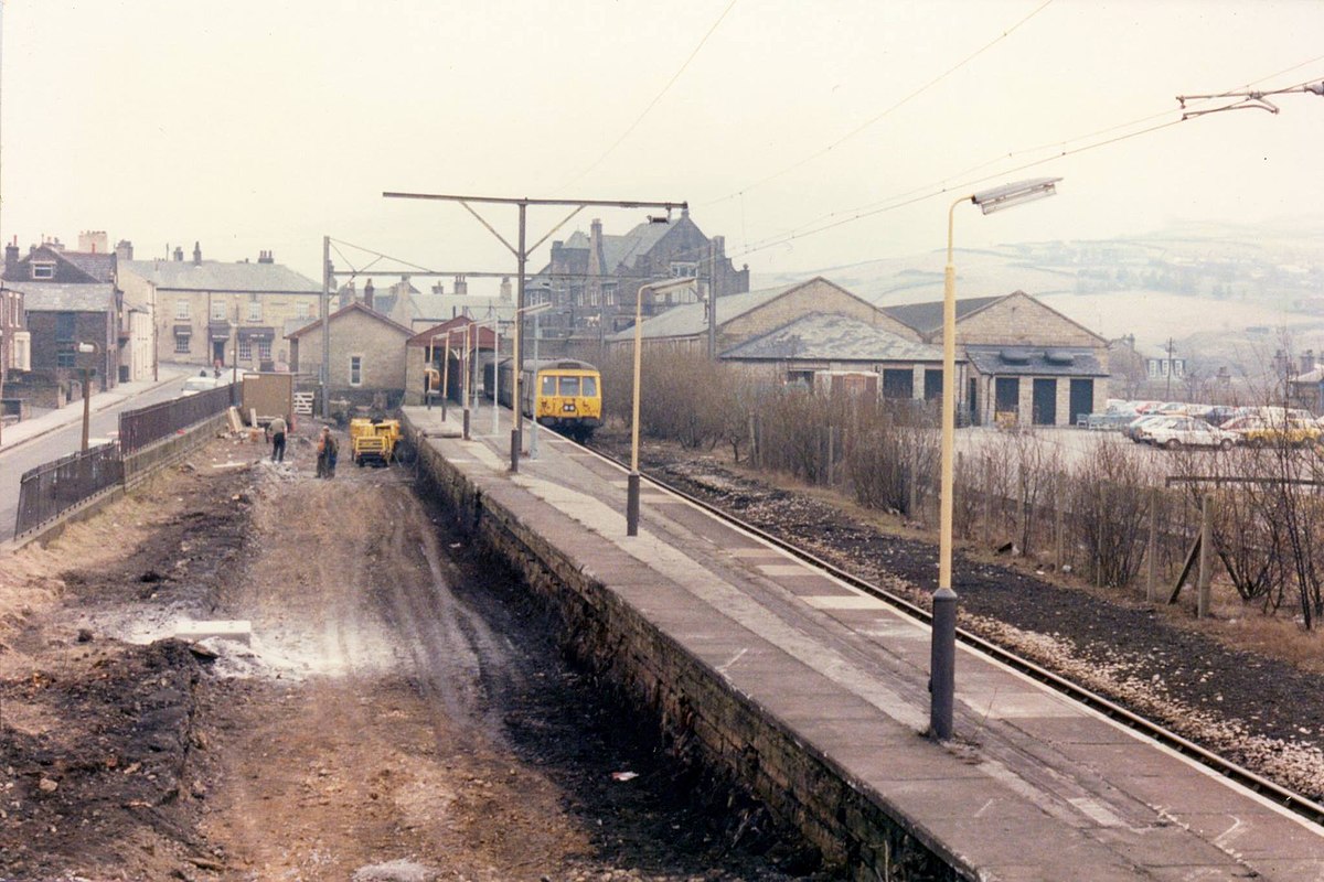
Glossop station 1985, photo taken by Rcsprinter123 and reproduced under Wikimedia Creative Commons Licence. The trees have been cleared from the overgrown platform on the left, which would become the one and only main platform. The platform on the right closing and becoming an extension to the car park.
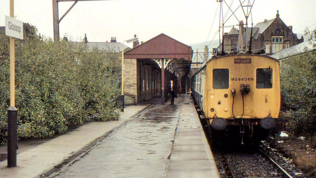
2962 ~ Railway Station~B&M & Railway Station ~ (1967)
Glossop station October 1983, photo taken by Geoffrey Skelsey and reproduced under Wikimedia Creative Commons Licence. In the distance to the left is Glossop Conservative Club.
2961 ~ Railway Station~B&M & Railway Station ~ (1983)
Glossop station October 1983, photo taken by Albert Bridge and reproduced under Wikimedia Creative Commons Licence. In the distance to the right is Glossop Conservative Club.
2960 ~ Railway Station~B&M & Railway Station ~ (1974)
6 May 1974 - Renamed Glossop
2959 ~ Railway Station~B&M & Railway Station ~ (1922)
10 July 1922 - Renamed Glossop Central
2958 ~ Railway Station~B&M & Railway Station ~ (1845)
9 June 1845 - Opened as Glossop for goods only
30 June 1845 - Opened for all traffic
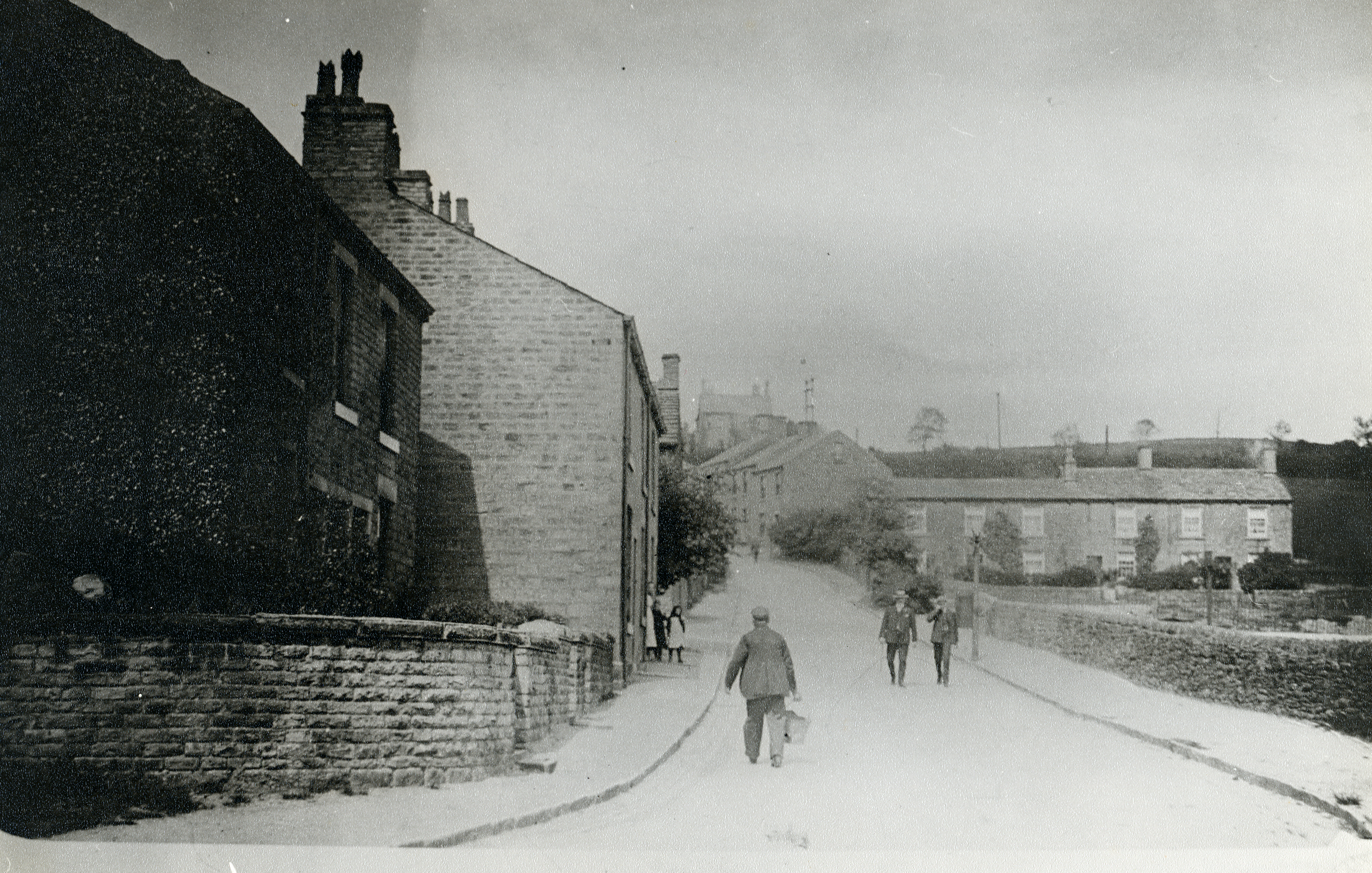
2957 ~ Primrose Lane~ ~ (1930)
.jpg)
This photo was taken on Primrose Lane, an area called Bridgefield were Long Clough Brook passes under the road, looking towards Turnlee Road, the houses on the right still remain but the others have been replaced with newer houses, a bit further down the road on the right would be Simmondley New Road, while the brook is on the left.
2956 ~ Spire Hollin~ ~ (1904)
.jpg)
This building looks like the large house on Spire Hollin, the date stone (on the current building) between the two roof windows reads "BETHRAPHA AD 1904", Bethrapha being a biblical name.
2955 ~ Spire Hollin~ ~ (1908)
Kelly’s Directory 1908
Beth-Rapha Home of Rest (Rev. Richard Howton, pastor), Spire Hollin
2954 ~ Spire Hollin~ ~ (1925)
Kelly’s Directory 1925
Howton Rev. Richard (Gospel Union), Beth Rapha, Spire Hollin
2953 ~ Spire Hollin~ ~ (1936)
Kelly’s Directory 1936
Gaunt Rev. Albion Sydney (pastor, Church of the Foursquare Gospel), Bethrapha, Spire Hollin
Elim Four Square Gospel Alliance Home (Miss M. F. Barbour, supt.), Bethrapha, Spire Hollin
2952 ~ Spire Hollin~ ~ (1932)
Kelly’s Directory 1932
Elim Four Square Gospel Alliance Home (Miss Barber, supt.), Bethrapha, Spire Hollin
2951 ~ Old Glossop~Hawkshead Mill ~ (1960)
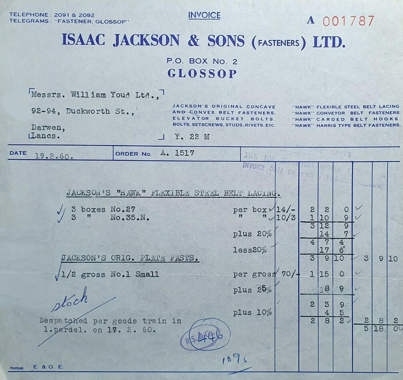
An invoice dated 19 February 1960 for 6 boxes of Jackson’s "Hawk" flexible steel belt lacings and half a gross (72) small Jackspn’s original plate fastenings, costing a total of 5 pounds and 18 shillings, dispatched in one parcel via goods train to Darwen, Lancashire. Note that Isaac Jackson offered a 2.5% discount if the invoice was paid within 7 days or 1.25% by monthly account.
2950 ~ Old Glossop~Meadow Mill ~ (1881)
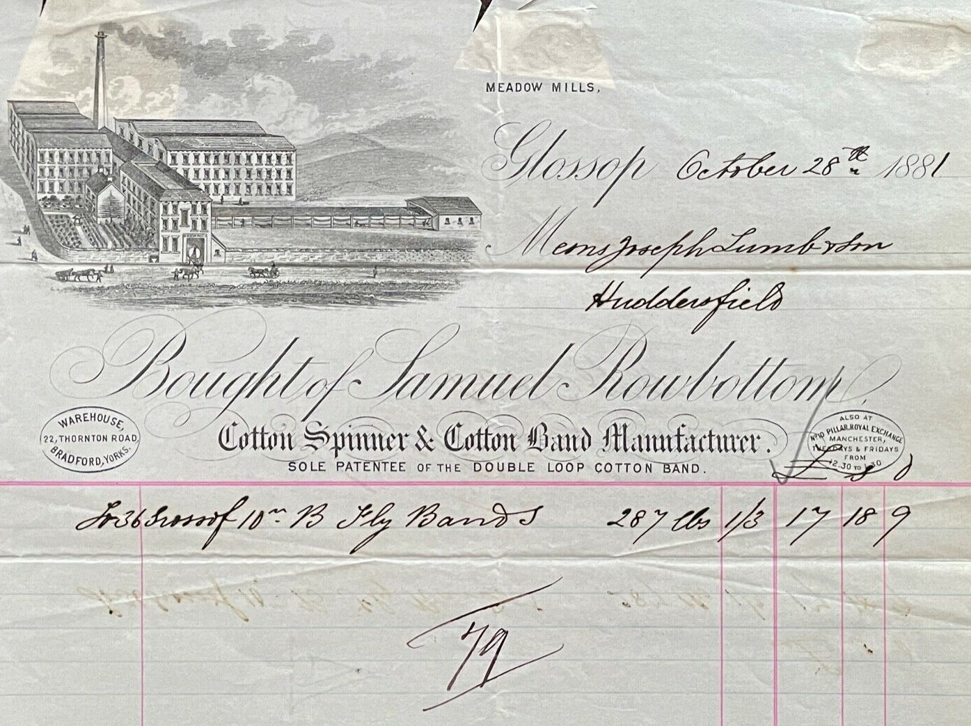
An invoice for 287 fly bands used in the cotton mill costing 17 pounds, 18 shillings and 9 pence, about £1,500 in 2020.